Tulum 2000 Project
Tulum 2000 Project
BY CHRIS WERNER
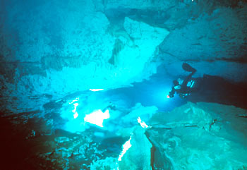 |
| Tulum Cave Passage. Photo ©Steve Auer |
During August 2000, a team of scientists and support divers from the Exploration Research Institute (ERI) conducted an eleven-day sampling project in the underwater caves of Mexico's Yucatan Peninsula. They were interested in the geochemical processes associated with freshwater/saltwater mixing zones in the aquifer along the Caribbean coast, and their influence on cave development. ERI researchers were primarily interested in geochemical processes in active subsurface drainage karst systems. Using datasonde instruments, in conjunction with DIR cave diving techniques, an extensive data set was collected to be used, along with laboratory water sample analyses, in clarifying the complex chemical mixing processes. The team was lead by Chris Werner, with the scientific sampling coordination headed by Kris Esterson, both serving as the Principal Investigators for the project. Steve Auer served as the Chief Photographer for the project. Team members all had extensive experience dry caving or cave diving.
A primary goal of ERI is to bridge the gap between sound scientific research and competent, safe exploration of Earth's more remote and hostile environments. Relevant contributions by knowledgeable researchers have been hindered by the lack of data acquisition within the environment of subaqueous caves. In the field of karst science, there has been significant progress in developing a comprehensive theory for phreatic cave development. Recently, the ERI Principal Investigators have focused on mixing processes in the phreatic zone and the resulting potential for carbonate dissolution below the water table. The dissolution processes associated with mixing zones have the potential to greatly increase secondary porosity and permeability within carbonate aquifers. This mechanism for carbonate dissolution at depth has interesting implications for the development of carbonate aquifers and petroleum reservoirs, as well as for the processes of speleogenesis (cave formation).These aqueous mixing processes operate in a wide range of locations, such as the peninsulas of Florida and the Yucatan, as well as Caribbean Islands such as Cuba, Jamaica, Bermuda, and the Bahamas. The coastal karst aquifer of the northeastern Yucatan peninsula has a great variety of easily accessible underwater caves, providing a nearly ideal location in which to study these processes. The ERI researchers decided to base the field study in an area near the small coastal town of Tulum.
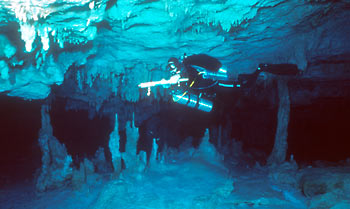 |
| Water Sampling. Photo ©Steve Auer |
This area contains several cave systems that are among the longest explored underwater caves in the world. Many of the caves are relatively shallow, sometimes only a few meters beneath the land surface, and are open to the surface in karst windows, springs, or sinks called cenotes. During periods of lower sea level, these shallow caves were dry; many still retain speleothems, such as stalactites and stalagmites, which were formed during this time. Today, the cave passages are flooded, due to the current higher sea level. The aquifer consists of a thin body of fresh meteoric water overlying deeper saline water. The two water bodies are divided by one or more haloclines. Discharge from sabanas, or treeless swamps, produces additional local variation in groundwater chemistry. Additional complexity is introduced by various physical mixing processes that combine waters of different salinities to create distinct zones of intermediate composition.
The goals of the Yucatan ERI project were to characterize the physical and chemical nature of the waters in these cenotes and the connected karst conduits. The team focused its study on obtaining water samples and in situ chemical measurements around the unique mixing zones found in this coastal aquifer. Ultimately, the team has been able to use the data gathered to calculate saturation indices for the mixing zone waters; this, in turn, will enable them to quantify the potential for additional carbonate dissolution due to mixing processes. In order to complete the saturation index equations, the team measured temperature, specific conductance, and pH. In the planning of this project, ERI researchers searched for the proper instrumentation that would enable them to measure these parameters in situ. To collect individual water samples in the caves and then bring these up to the surface for testing would, as other projects had done, greatly reduce the number of sites that could be examined, and potentially introduce greater error. The datasonde proved to be the perfect solution for in situ measurements in demanding field conditions. The MiniSonde™, provided by Hydrolab, a chief sponsor of the project, was equipped for measuring depth, dissolved oxygen, specific conductivity, pH, temperature, and oxidation-reduction potential. Although the focus of its study was the inorganic chemistry of the mixing zones, nonetheless, ERI planned to use the dissolved oxygen and oxidation-reduction potential measurements as a rough gauge of the role of biologic activity in these zones.
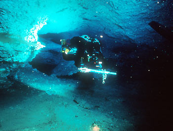 |
| Using the MiniSonde. Photo ©Steve Auer |
When the team arrived at a site of interest, the diver disconnected the instrument from his harness and ascended to the ceiling of the passage. The diver would then descend slowly from the ceiling to the floor of the passage as the MiniSonde™ recorded measurements, effectively creating a column of water-chemistry measurements. On average, the team conducted approximately four columns per dive and recorded 1000-2000 measurements of all selected parameters mentioned above.
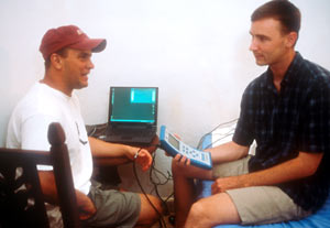 |
| Downloading Data . Photo ©Steve Auer |
Once the dive was completed, a download of the data collected from the instrument was transferred to the Surveyor 4a, simplifying all field operations. (The field conditions in the Yucatan jungle were less than ideal for using a laptop computer.) Each evening, the data was exported from the Surveyor 4a into a laptop computer. This ease of data management allowed for critical review each evening, and facilitated the making of relevant observations and adjustments that could easily be incorporated the following day.
In conjunction with the MiniSonde™ measurements, the team also collected 30 water samples for later analysis by ICP-MS and ion chromatograph. It used the instrument to record in situ measurements from each of the sample locations. In such a way, the ERI team had a record of the actual water chemistry at the exact time and location for each water sample. By the conclusion of the project, the team had logged over 15,000 measurements from 10 cave systems with the MiniSonde™. It knew that successful digital data management in the field would be a critical factor in the success of the project. In addition to the scientific data collection, the team focused on documenting, both by photography and videography, the unique environment of the underwater caves of the Yucatan Caribbean coast. ERI Chief Photographer Steve Auer obtained the photographic images. Working closely with Chris Werner, Auer was able to capture tremendously useful images that will aid other scientists and researchers, who are not able to visit these remote regions, in understanding the complex hydrogeology and geochemistry of the region. Underwater video was also taken throughout the project. Using video lights manufactured by Extreme Exposure, another primary sponsor of the project, team leader Chris Werner and support diver Herve Deschamps captured over 15 hours of video. The team documented several interesting features, including passage cross-sectional morphology, physical mixing zones and several dye traces performed by Kris Esterson. Based on its findings, ERI is currently in the process of preparing papers, both scientific and informational, for publication throughout the next year. The data collected is also in the process of being analyzed in order to reach conclusions regarding the team's project objectives.ERI would like to thank the following sponsors for their contributions and support in making this project possible: Global Underwater Explorers, Hydrolab, Aquatography and Extreme Exposure.
All rights reserved.
