Natural Bridge - St. Marks River Rise Exploration
Natural Bridge - St. Marks River Rise Exploration
Update by Chris Werner
Summer 2006
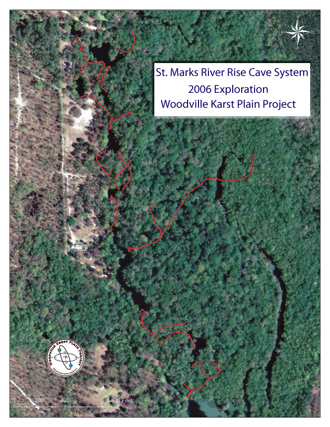
As conditions in the Woodville Karst Plain began to clear in early January 2006, a reconnaissance dive by Chris Werner and Todd Kincaid into the St. Marks River Rise revealed that conditions at even this most tannic of springs was improving. The dive was part of an initiative to place tubing for the City of Tallahassee Southeast Spray Field tracer test in order to effectively sample for dye from the surface. During the dive, visibility was approximately 10 ft, the best seen in a close to a decade. Field personnel would be checking the River Rise twice weekly throughout the year, allowing careful documentation of the visibility for the better part of the Spring and Summer.
As conditions improved, Chris Werner, Scott Cox and Jim Miller made initial exploration dives on May 5 and June 3, 2006. Conditions were between 5 and 10 ft of visibility, with strong flow. Though there were reports of exploration previously, no line was found in the cavern or cave. The initial exploration led to the discovery of two large phreatic conduits leading to the northeast, surfacing on two different sides of a large nearby sinkhole. The teamed laid a little over 1000 ft of line in the two outings.
In conjunction with these dives, the landowners of the adjacent parcels contacted Chris Werner about conducting an assessment of the hydrogeologic importance of the Natural Bridge - St. Marks River Rise area. In association with Hazlett-Kincaid Inc., the WKPP was permitted to explore, survey and map the underwater caves on all adjoining parcels of land, the data and finding to be incorporated into a final report for the landowners. The property has approximately 15 sinkholes with its northern terminus being the St. Marks River Sink approximately 1.3 km straight-line distance north from the River Rise.
Armed with the above agreement, knowledge of the potential for large phreatic cave and the fact that the initial exploration was relatively shallow, approximately 110 ft at its deepest depth, the team of Chris Werner and Scott Cox returned on June 9, 2006 to push the lead in the nearby sinkhole. The team laid an additional 850 ft of line in very tough conditions, with less than 5 ft of visibility. As Cox remarked jokingly, "The visibility was approximately 4 1/2 to 5 ft, but no more." The team had found another large phreatic passage trending north and connected it with a surface run to the north.
On June 11, 2006, Werner and Cox returned to explore a surface boil on the newly connected surface run. The team entered a large phreatic tube at approximately 80 ft depth. With Werner laying the line and scootering on the left wall, the team got itself into a small canyon like passage with limited flow. Werner surveyed out while Cox set down arrows and placed the line to avoid traps. Once back in the basin, the team recalculated gas and decided to go back to where they had lost the flow. Werner tied in and made a bee-line for the opposite side of the room, there the visibility improved to 20 ft. Soon the reel was empty, but luckily Cox had another reel tucked away. The team tied in the other reel and Werner proceeded into a spring tunnel, up over a small breakdown mound and then straight down for 30 ft into a spring tunnel measuring 8 ft by 8 ft in cross-section with an average depth of 105 ft. The flow was like a fire hose, the team made its way along the passage for an additional 500 ft and tied off on a nice wrap. The team called the dive on gas, Werner surveyed out and then they proceeded with their decompression in the basin. High-fives were given once the team reached the surface as the mood was all smiles and congratulations.
Unfortunately, the good conditions would not last. On June 17, Werner and Cox returned to find that rain in the area had affected much of the river dominated passages. Visibility was back down to below 5 ft. The team proceeded to continue exploration in the spring tunnel found the prior week. With flow still raging, they managed to add 500 ft of line before encountering a tight restriction. They then proceeded to the far northern reach of the run following a short lunch and connected another four sinkholes in a stretch of the river that was dominated by clear spring flow.
The following weekend, on June 25, 2006, Werner and Pina Porceddu laid approximately 600 ft of line connecting another two sinks and cleaned up some survey left from the previous weekend. On July 1 and 2, 2006, the team of Werner, Porceddu and John Rose laid over 1200 ft of line connecting another four sinkholes near the northern edge of the property. Conditions had improved to nearly 20 ft of visibility, but a sticking compass slowed the survey. The long weekend provided an opportunity to obtain water samples for analysis and resurvey some stretches of line, this time with a new compass.
On July 8, 2006, Werner and Porceddu connected another two sinks, putting in over 700 ft of line. They were joined on June 9, 2006 by Derek Bennett. The three-person team laid an additional 750 ft of line and connected another two sinks. They team took time to resurvey a few exploration lines and search for leads in a newly discovered spring tunnel. Bennett joked to Werner following the dive, "The visibility was much less than 15 ft, you said the visibility was good, but you sure have a way of sniffing out where the passage was headed." Everyone laughed as Werner replied, "15 feet is good visibility here!"
On July 15, 2006, the team of Werner and Rose entered the blackest sinks at the northern end of the property. An attempt was made to connect to the St. Marks Sink as an extended period of drought had allowed water levels to drop and flow from the river to diminish significantly. Werner tied in on a cypress knee, and with less than 3 ft of visibility, laid 250 ft of line emerging at the St. Marks Sink. Rose surveyed behind him, both surfacing in the some of the most polluted waters the two veterans had ever seen. Both were careful to avoid the fishing line, floating garbage and multitude of snakes.
Following a short surface interval, the team started into the other black sink. As they entered, Werner stayed on the left side, knowing that the right side of the passage will likely lead to the St. Marks Sink again. Instead of being very dark, the left side of the passage had visibility topping out at over 30-40 ft, the best seen thus far during the entire exploration. After some route finding in a few large rooms, Werner came across a massive 25 ft x 25 ft going tunnel headed north. Followed by Rose surveying, the team dumped 700 ft of line on a single stage at an average depth of 110 ft, calling the dive on gas. They were joined by Derek Bennett on July 16, 2006. Derek shot video on the dive as the team laid an additional 1200 ft of line. The northwestward trending tunnel was wide open at the end of the line, with a size of approximately 15 ft high and 30 ft wide and phreatic in cross-section.
In eight limited outings and while working in severely limited visibility for the majority of the dives, the WKPP explored more than two miles of new cave passage and connected more than 13 surface sinkholes and springs. The large passage headed north from the area holds the potential for extended exploration and mapping.
Links
- St. Marks River Rise Photo Gallery
- Provisional map of 2006 exploration
- Tallahassee Democrat article on the Natural Bridge history and exploration
