Hydrologic Connections: Mapping Groundwater Flow Patterns in the WKP
Hydrologic Connections
mapping groundwater flow patterns in the wkp
BY TODD KINCAID
Introduction
Clean fresh water is rapidly becoming one of the most precious natural resources worldwide. Groundwater, water beneath the land surface that occupies and flows through variably sized void spaces in rock and soil, accounts for 22% of the world’s total fresh water supply as compared to all surface water bodies at 0.3%. In particular, Florida depends on groundwater resources for 87% of the public water supply and 94% of the dispersed private supply (Fernald and Patton, 1984). Given this level of dependence on groundwater resources, groundwater or "aquifer" protection is now one of the most important issues facing local, state, and federal land use planners.
The Floridan aquifer is one of the largest aquifers (geologic formation(s) containing appreciable quantities of groundwater) in the United States and contains 27 of the 78 largest class of springs found in North America (Lane, 1986). All 27 of these large springs discharge water from extensive water-filled cave systems dissolved out of limestone bedrock. These cave systems are of particular interest because they transmit large quantities of water from upland recharge areas to spring discharge points on Florida’s major rivers such as the Suwannee, the St. Johns, the Santa Fe, the Oklawaha, and the Withlacoochee.
The relationship between springs and cave development in the Floridan aquifer is therefore important to groundwater resource conservation plans because it defines both the area of recharge that contributes to spring flows and the potential for rapid ground water / surface exchange. The crux of the problem facing resource managers is the ability to accurately predict groundwater velocities through subsurface caves (karst) that rapidly transmit water through a network of interconnected conduits. Such conduits cannot be mapped from the surface and significantly hamper traditional hydrologic modeling efforts. Toward this end, GUE has been working with the Woodville Karst Plain Project conducting purposeful exploration and research to document conduit morphologies in Wakulla cave and relate them to groundwater flow patterns through the larger Woodville Karst Plain.
This paper synthesizes a map of Wakulla cave compiled from surveys made by the WKPP and earlier explorers between 1985 and 1998, direct observations of the flow system, reported water chemistries, and regional hydrologic data to produce a regional groundwater flow map of the Woodvile Karst Plain. Afterward, a new model is proposed for the development of water-filled caves in general and Wakulla cave in particular.
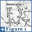 Wakulla cave is comprised of a dendritic network of conduits of which 8,770 m have been surveyed and mapped (Figure
1). The largest conduit, labeled A and O on Figure 1 trends
south from the spring / cave entrance for over 5.5 km (Jablonski,
personal communication) of which 3.2 km have been mapped. Five
secondary conduits labeled B, C, D, K, and M on Figure 1, measure
4.3 km in combined length and intersect the larger conduit. Eleven
smaller conduits measuring 1.2 km in combined length connect to the
secondary conduits. Many of the conduits have not been fully
explored (Jablonski, personal communication).
Wakulla cave is comprised of a dendritic network of conduits of which 8,770 m have been surveyed and mapped (Figure
1). The largest conduit, labeled A and O on Figure 1 trends
south from the spring / cave entrance for over 5.5 km (Jablonski,
personal communication) of which 3.2 km have been mapped. Five
secondary conduits labeled B, C, D, K, and M on Figure 1, measure
4.3 km in combined length and intersect the larger conduit. Eleven
smaller conduits measuring 1.2 km in combined length connect to the
secondary conduits. Many of the conduits have not been fully
explored (Jablonski, personal communication).
The conduits are characterized as long tubes. The diameter and depth of any tube is consistent through space but larger chambers of varying geometries can divide individual or joining tubes. An average velocity of approximately 1 m/sec was estimated by calculating the rate at which a resting diver was propelled in the down-gradient direction. Water velocities in the largest conduits were smaller but remained large enough to propel a resting diver. Scallop marks on the cave walls were observed throughout the cave and indicate the persistence of large ground water through-flow velocities for an extended period of geologic time.
The pattern of ground water flow through Wakulla cave is complicated by the fact that the largest conduits trend down-gradient from the spring discharge point. Flow directions compiled from observations made by cave divers indicate the presence of a ground water divide that crosses the cave between conduits D and M (Figure 1). Reduced ground water velocities encountered in conduit A after the junction with conduit D indicate that the divide is better characterized as a broad zone that crosses the cave at a distance of between 1 and 2 km from the spring. Variations in ground water velocities observed at different times throughout the divide zone indicate that the location of the divide fluctuates.
Direct connections to surface water sources are indicated in conduits A, K, M, and O by water clarity reductions that occur in as little as one day following local storms or prolonged regional precipitation (Jablonski, personal communication). Even during periods when turbid water discharges at the spring, clear water was typically observed discharging into conduit A from conduits B, C, and D (Jablonski, personal communication). Uranium isotopic compositions measured by Macesich and Osmond (1989) support that observation by showing that conduit A has a surface water signature while conduit B has a signature typical of regional ground water.
Cave Development
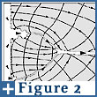 Flow and storage-dominated
caves are two end-members along a continuum of saturated cave
development (Figure
2) that occurs during the karstification of a carbonate aquifer
(Kincaid, 1999). The conceptual model described below will show
that cave evolution progresses through four stages. The key
hydraulic variable that determines cave morphologies at each stage
of development is ground water velocity.
Flow and storage-dominated
caves are two end-members along a continuum of saturated cave
development (Figure
2) that occurs during the karstification of a carbonate aquifer
(Kincaid, 1999). The conceptual model described below will show
that cave evolution progresses through four stages. The key
hydraulic variable that determines cave morphologies at each stage
of development is ground water velocity.
Initiation Stage
The development of saturated caves is self-initiated (not dependent on processes external to the flow system). The process is caused by positive feedback loops between flow and dissolution that are created by small and random variation in the initial distribution of permeabilities. Dissolution into zones of larger permeability enhances dissolution that, in turn, enhances the convergence of flow into those zones (Figure 2a). The feedback process is both geochemical and hydrodynamic and was first described by Ortoleva and others (1987).
As the flow system evolves, caves develop at both the recharge (up-gradient) and discharge (down-gradient) ends (Kincaid, 1999). At the up-gradient end, the feedback process is predominantly geochemical. Random variations in the permeability field (i.e. porosity or fracture aperture variation) yield fingers of enhanced dissolution that advance ahead of the average dissolution front (Ortoleva et al., 1987; Hanna and Rajaram, 1998). The dissolution fingers create preferential zones of dissolution that eventually develop into caves.
At the down-gradient end of the flow system, the feedback process is hydrodynamic and is enhanced by mixing corrosion (Bogli, 1980; Dreybrodt, 1981). Discharge is concentrated into zones of slightly enhanced permeability which eventually develop into springs. As dissolution proceeds, hydraulic head is reduced because the zones are connected to the springs. Local hydraulic gradients adjust to the new head configuration generating fingers in the dissolution front that capture more flow from the surrounding aquifer. Since most of the flow is focused toward the most up-gradient part of the finger, reaction infiltration instability and mixing corrosion promote the development of near-linear conduits that grow in the up-gradient direction.
Immature Stage
Caves forming at the up-gradient and down-gradient ends of a flow system develop different physical and hydraulic characteristics owing to different ground water through-flow velocities (Figure 2b).
Largest through-flow velocities occur in the dissolution fingers developing at the down-gradient end of a flow system because of steeper gradients between the aquifer matrix and the spring discharges. Large through-flow velocities promote the development of tubular conduit profiles because convergence of flow and dissolution are maximized in the most up-gradient section of the largest dissolution finger. Cave expansion at the down-gradient end of a flow system will proceed faster than at the up-gradient end because discharge of water from the aquifer at springs ensures that convergence of flow and thus ground water velocities, mixing corrosion, and dissolution are maximized. Conduits in these caves typically become larger in the down-gradient direction toward the spring discharge. These types of caves are classified as "flow-dominated" (Kincaid, 1999) and include the majority of the explored water-filled caves in Florida.
In contrast, small through-flow velocities occur at the up-gradient end of a flow system wherein water flowing through the dissolution fingers must re-enter the aquifer matrix through smaller permeability features such as a network of distributed fractures. Slower through-flow velocities promote irregular cavity shapes because dissolution is distributed throughout the down-gradient end of the dissolution finger where flow is re-entering the aquifer matrix. These caves develop in the down-gradient direction from recharge sources as a result of carbonate dissolution by calcite aggressive in-flowing water. Cave expansion is slower because the slow ground water velocities inhibit dissolution wherein through-flowing water quickly approaches saturation with respect to CaCO3 causing the dissolution reaction rate to drop (Weyl, 1958; Berner and Morse, 1974; Plummer et al., 1978; Groves and Howard, 1994a). The resulting caves are typically large voluminous chambers with little or no conduit type passages (Kincaid, 1999). Caves in Florida that can be classified as storage-dominated include Dipolder #s 2 and 3, Gunpowder, and Blue Grotto.
Mature Flow-dominant Stage Given enough geologic time, immature flow and storage-dominated caves will join and form a mature flow-dominated cave that connects recharge sources with the most prominent spring (Figure 2c). The resulting cave is termed flow-dominated because it becomes the primary flow path through the aquifer. Hydraulic gradients adjust such that flow converges on the conduit, which conveys the water to a spring discharge. This is the case with Wakulla cave that collects most of the groundwater flow through the Woodville Karst Plain and directs it to Wakulla spring and submarine springs in the Gulf of Mexico (Kincaid, 1999).
Mature Storage-dominant Stage
If the geologic environment remains stable, flow-dominated caves will evolve into a mature saturated karst as a result of continued cave expansion (Figure 2d). Conduits expand until the transmission capacity of the cave equals the recharge rate. Hydraulic gradients in the aquifer reduce and hydraulic head potentials straighten which reduces the convergence of flow into the cave thereby reducing the rate of cave expansion. Through-flow velocities reduce which causes the morphologic structure of the cave to evolve toward irregular cavities and chambers similar to those described in the storage-dominated caves and away from tubular shaped conduits that characterized the cave during the earlier flow-dominant stage. In addition to functioning as a preferential flow path, the cave becomes large enough to provide significant ground water storage.
Note that widespread dissolution at the down-gradient end of the flow system will be particularly enhanced in coastal aquifers where fresh water / seawater mixing increases dissolution rates. Cave development in the Yucatan Peninsula is a perfect analog wherein multiple conduits have coalesced in the down-gradient direction forming broad zones of extensive dissolution that have lost all semblance of conduit structure (Back et al., 1986; Stoessell et al., 1989; Whitaker and Smart, 1997).
Development of Wakulla Cave Wakulla cave is an important example of a cave pattern that has resulted from hydraulic conditions responding to geologic processes. The most important characteristics include the down-gradient rather than up-gradient trend of the largest conduit away from the spring discharge and the presence of a ground water divide that crosses the conduits. It is important to recognize that these characteristics arose from flow systems that adapted to sea level rise and the erosion of an overlying confining layer. The present cave pattern and morphology are a result of cave development that occurred in both past and present flow systems.
As described in a previous section, Wakulla cave is a branching flow-dominated cave that has developed in the Floridan aquifer under the Woodville karst plain of north Florida. In terms of the proposed model, the cave has evolved into a flow-dominant stage wherein the conduits connect recharge sources with a spring. The geologic processes active on the Florida platform that have affected the development of Wakulla cave include, deposition of carbonate and siliciclastic rocks, sea level fluctuations, and subsequent erosion of the siliciclastic rocks that had provided an upper confining layer to the Floridan aquifer.
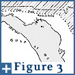 The Florida platform
extends for more than 200 km into the present Gulf of Mexico and is
defined by the 300 ft bathymetric contour (Figure
3). Carbonate sedimentation on the northwestern part of the
platform was continuous between mid-Cretaceous and late Oligocene
times (Scott, 1992). During the Miocene Epoch, siliciclastic
sediments were transported onto the platform by rivers and
distributed by longshore and other currents (Scott, 1992).
Subsequent subaerial exposure resulted in the evolution of the
carbonate rocks into the Floridan aquifer for which the overlying
Miocene siliciclastic rocks, described as the Hawthorne Formation,
provided a laterally extensive confining layer.
The Florida platform
extends for more than 200 km into the present Gulf of Mexico and is
defined by the 300 ft bathymetric contour (Figure
3). Carbonate sedimentation on the northwestern part of the
platform was continuous between mid-Cretaceous and late Oligocene
times (Scott, 1992). During the Miocene Epoch, siliciclastic
sediments were transported onto the platform by rivers and
distributed by longshore and other currents (Scott, 1992).
Subsequent subaerial exposure resulted in the evolution of the
carbonate rocks into the Floridan aquifer for which the overlying
Miocene siliciclastic rocks, described as the Hawthorne Formation,
provided a laterally extensive confining layer.
Sea level fluctuations have caused transgressions and regressions over the Florida platform several times since the deposition of the Hawthorne Formation. Submarine springs on the Florida platform (Figure 3) indicate that karstification had established preferential flow routes through the Floridan aquifer prior to the last sea level rise.
Landward erosion of the Hawthorne Formation exposed the
underlying carbonates to infiltration of surface waters and caused
the development of karstic ground water flowsystems. The erosional
boundary of the Hawthorne Formation creates a prominent topographic
scarp known as the Cody Scarp (Figure
3). Surface drainage across the scarp and onto the exposed
carbonates creates a zone of extensive karstification marked by
numerous caves, sinkholes, and disappearing rivers (Ceryak, 1981;
Spangler, 1981; Scott, 1981; Lane, 1986). The zone of
karstification has followed the landward migration of the scarp
leaving remnant caves and sinkholes on the evolving low carbonate
land surface. Fossil and archeological artifacts discovered inside
Wakulla cave but close to the spring discharge (Figure
4) indicate that the shaft that currently localizes Wakulla
spring is one of these remnant sinkholes.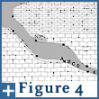
These facts combined with the present pattern and flow characteristics in Wakulla cave indicate that the largest conduits in the cave developed during a period of lower sea level and more seaward extent of the confining layer. Discharge from the aquifer was through the present submarine springs. Recharge was through a sinkhole that is currently Wakulla spring and was localized by the paleo-extent of the confining layer. The paleo-flow system caused dissolution of rock from the aquifer that culminated in the development of a flow-dominated cave that connected the sinkhole with the down-gradient spring(s). Precise timing of the cave development cannot be constrained beyond any of the periods of lower sea level that post dated the deposition of the Hawthorne formation during Miocene time.
Following the retreat of the confining layer and sea level rise, regional hydraulic gradients reduced forcing the evolution of the flow system into the current condition. The sinkhole that was the predominant source of recharge evolved into Wakulla spring. New sinkholes and karstic depressions like the Leon Sinks sinkholes developed farther up-gradient in the proximity of the retreating confining layer. The smaller conduits in Wakulla cave developed as a consequence of dissolution along flow paths connecting the newer sinkholes with Wakulla spring. The original conduits comprising Wakulla cave remained in the aquifer however, and provided preferential flow paths that connected the newly formed Wakulla spring with the down-gradient springs that were drowned by the rise in sea level. A ground water divide has developed across the cave where flow converging on the conduit from the northern part of the Woodville Karst Plain discharges at Wakulla spring while flow from the southern part of the region enters the conduit and flows farther down-gradient to the submarine springs.
Closing Note
The demand for clean fresh water in Florida continues to grow due to the ever-increasing statewide population and development. Those demands translate to increased withdraws from the Floridan aquifer and heavier loads of various waste related problems that must be mitigated. The importance of aquifer protection becomes all too apparent when one considers that the Floridan aquifer is one of the largest aquifers in the country yet much of south Florida is burdened by persistent water restrictions and groundwater quality is being adversely affected by saltwater intrusion and both point source (private, municipal, and industrial waste) and non-point source (agricultural) pollution.
The problem of protecting and in some cases remediating groundwater resources in the Floridan aquifer is further complicated by its karstic structure. Traditional methods of characterizing groundwater flow are proving inadequate because of their inability to describe or predict flow through countless unseen conduits in the subsurface. Fundamentally, the problem boils down to the development of an accurate conceptual model of groundwater flow through specific regions of the Floridan aquifer.
The crucial step that needs to be taken is creating an alliance between cave explorers and researchers like the WKPP and the GUE and hydrological and geochemical scientists. Conduit maps produced by the explorers and their observations of the flow characteristics represent the best first-hand data on the dynamics of the flow system. Once this is recognized, geochemists can take advantage of cave-divers to collect water samples from discrete conduits and eventually fingerprint water sources. The combined sets of data can then be used to refine or, when necessary, develop conceptual and numerical models of groundwater flow between identified recharge and discharge sources. Such models will then become the tool of choice for land and water resource managers to guide future protection, remediation, and development strategies.
References
Back, W., Hanshaw, B.B., Herman, J.S., and Van Driel, J.N., 1986, Differential dissolution of a Pleistocene reef in the ground-water mixing zone of coastal Yucatan, Mexico, Geology, vol. 14, pp. 137-140.
Berner, R.A. and Moorse, J.W., 1974, Dissolution kinetics of calcium carbonate in sea water, IV, theory of calcite dissolution, American Journal of Science, vol. 274, pp. 108-134.
Bogli, A., 1980, Karst Hydrology and Physical Speleology, Springer-Verlag, New York.
Ceryak, R., 1981, Significance of the Cody Scarp on the hydrogeology of north central Florida in Karst hydrogeology and Miocene geology of the Upper Suwannee River basin, Hamilton County, Florida, Field Conference Guidebook, Southeastern Geological Society, Tallahassee, Florida, pp. 24-29.
Dreybrodt, W., 1981, Mixing corrosion in CaCO3-CO2-H2O systems and its role in the karstification of limestone areas, Chemical Geology, vol. 32, pp. 221-236.
Fernald E.A. and Patton, D.J., 1984, Water Resources Atlas of Florida, Library of Congress Catalog No. 84-081758, Institute of Science and Public Affairs, Tallahassee, Florida.
Groves, C.G. and Howard, A.D., 1994, Minimum hydrochemical conditions allowing limestone cave development, Water Resources Research, vo. 30, no. 3, pp. 607-615.
Hanna, R.B. and Rajaram, H., 1998, Influence of aperture variability on dissolutional growth of fissures in karst formations, Water Resources Research, vol. 34, no. 11, pp. 2843-2853.
Jablonski, J., 1999, 15 S. Main St, High Springs, FL, ph. 800-762-3483, Email jjcave@gue.com, personal communication.
Kincaid, T.R., 1999, Morphologic and fractal characterization of saturated karstic caves, Ph.D. Dissertation, University of Wyoming, Laramie.
Lane, E., 1986, Karst in Florida, Special Publication No. 29, Florida Geological Survey, Tallahassee, Florida, 100 p.
Macesich, M. and Osmond, J.K., 1989, Uranium isotopic study of Wakulla Springs, Abstracts with Programs, Geological Society of America, vol. 21, no. 3, pp. 49.
Ortoleva, P., Chadam, J., Merino, E., and Sen, A., 1987a, Geochemical self organization I: reaction-transport feedbacks and modeling approach, American Journal of Science, vol. 287, pp. 979-1007.
Olsen, S.J., 1958, The Wakulla cave, Natural History, vol. 67, no. 7, pp. 396-403.
Plummer, L.N., Wigley, T.M.L., and Parkhurst, D.L., 1978, The kinetics of calcite dissolution in CO2-water systems at 5 to 60 (C and 0.0 to 1.0 atm CO2, American Journal of Science, vol. 278, pp. 179-216.
Scott, T.M., 1981, The Hawthorn Formation of North Florida in Karst hydrogeology and Miocene geology of the Upper Suwannee River basin, Hamilton County, Florida, Field Conference Guidebook, Southeastern Geological Society. Tallahassee, Florida, pp. 15-23.
cott, T.M., 1992, A geological overview of Florida, Open File Report No. 50, Florida Geological Survey, Tallahassee, Florida, p. 78.
Spangler, D.P., 1981, Florida’s water Resources with Particular Emphasis On Ground water, Proceedings of the First Annual Symposium on Florida Hydrogeology, Northwest Florida Water Management District, Havana, Florida.
Stoessell, R.K., Ward, W.C., Ford, B.H., and Schuffert, J.D., 1989, Water chemistry and CaCO3 dissolution in the saline part of an open-flow mixing zone, coastal Yucatan Peninsula, Mexico, Geological Society of America Bulletin, vol. 101, pp. 159-169.
Weyl, P.K., 1958, The solution kinetics of calcite, Journal of Geology, vol. 66, pp. 163-176.
Whitaker, F.F. and Smart, P.L., 1997, Groundwater circulation and geochemistry of a karstified bank-marginal fracture system, South Andros Island, Bahamas, Journal of Hydrology, vol. 197, pp. 293-313.
All rights reserved.
