Fontaine du Truffe: Getting Involved with Cave Surveying
Fontaine du Truffe: Getting Involved with Cave Surveying
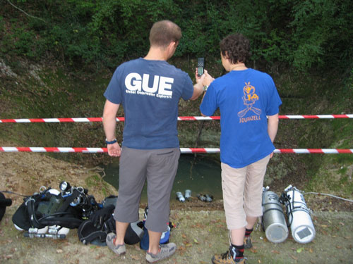
Photography: Uli Kunz and Team Durazell
Team: Maren Isigkeit, Stephan Schlumbohm, Torsten Schnitter
That cave diving is more than just about traveling along a line and looking at formations was obvious to us since we started diving with GUE. While previously we had liked the stories about exploration and research, it was more about reading and watching what others were doing. Things changed when Chris Le Maillot took us through an afternoon workshop on cave survey techniques during our GUE Cave 2 class. We had a great time on the challenging cave dive solving challenges with good teamwork and quite some effort. We were so eager to draw our map after the survey dive to see what we would get from the collected data! It was then that we were sure we wanted to do more survey on our next trip to France, to gain further experience and repeat the fun.
It did not take long after the finish of the class to begin planning what we would need for our next dive—survey compass, measuring tape, survey notes…and a reel with 800ft of line, which had to be knotted. During this preparation we stayed in contact with Fred Devos from Zero Gravity, who mentored us to prevent us from making critical mistakes.
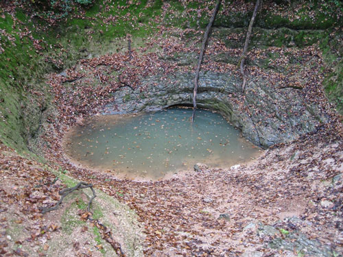
Arriving in the south of France, we were eager to start our little project surveying the first sump of Fontaine du Truffe. A beautiful shallow cave in the Lot area, it was perfect for our dive as it usually has great visibility, is tiny and shallow, but did not have any grade 3 survey data available to the public, as far as we knew. Getting into the cave was sometimes a bit of a challenge, especially with the low water level in summer, but we succeeded, even with the extra equipment we had due to the expected longer dive time and the survey stuff we needed. The survey line had to start in open water to give us a fixed reference (by GPS) for later data collections and to allow us to draw the survey map.
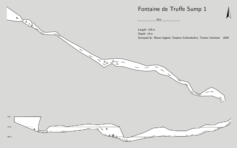
As a team of three divers, we divided the tasks into laying survey line, taking azimuth, and measuring distances between the placements and the walls (side to side and floor to ceiling). We worked for nearly 2.5 hours to survey 154 meters before reaching the end of the first sump. Even though it was difficult to get good data for the first few meters due to very bad visibility at the restriction at the entrance, we were happy about the data in total. Again with the help of Fred Devos, we created a map of the cave afterwards (using cave mapping software). Part of the data can be seen with the Google Earth geo-data file, which gives a very nice impression of the heading of the cave within the surrounding landscape.
It was very fun to do this survey and we gained a lot of experience from it. It is great to realize how the skills and procedures we learned and trained for fit into this dive and to use them to bring more knowledge about caves back to the surface. It’s no surprise, then, that we are already planning the next survey! A big thank you goes to Chris and Fred from Zero Gravity for the training and ongoing support. For those interested, Zero Gravity is offering a five-day survey workshop—which is now high on our wish list, as well.
Team Durazell – Stephan, Totti, and Maren
Sump 1, 147m (horizontal) respectively 154m (total)
Privacy Policy © 1998-2023 Global Underwater Explorers
